Mekong Delta and Phu Quoc · Ca Mau
Ca Mau travel guide: Cape Ca Mau, mangroves and U Minh forest
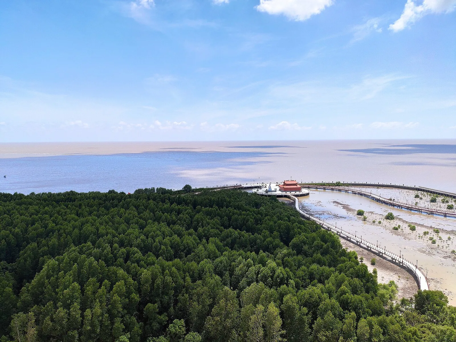
Ca Mau is where mainland Vietnam runs out. The Ho Chi Minh Road, which runs the length of the country, ends at a cape of mud and mangrove that is still growing into the sea, marked by a national coordinate post numbered GPS 0001 and a boat-shaped monument facing the water. Getting there takes effort — it is the far end of the Mekong Delta, a long way from the usual river towns — and the reward is not a sight so much as a landscape: tidal forests cut by channels, stilt houses, shrimp ponds under the trees and, on the west side of the province, the dark-water melaleuca swamps of U Minh. Come for the sense of reaching the end of the country, and stay long enough to get out on the water.
- Suggested time
- 2–3 nights
- Where to stay
- Central Ca Mau city; Nam Can or a Dat Mui homestay for the cape
- Season and timing
- Hot and humid all year, around 25–28°C on average; the wet season runs from May to November with afternoon downpours, and December to April is drier and easier for long boat days. Mud crab is at its best around the seventh and eighth lunar months, and migrating birds stop on the cape's mudflats in the northern winter.
The short answer
Stay two or three nights in Ca Mau city. Give one full day to Cape Ca Mau and the mangrove national park — the provincial portal lists it as a day trip from the city by road, with boat routes through the forest at the cape — and a second day to Hon Da Bac and the U Minh Ha melaleuca forest on the west coast. Sleep in central Ca Mau; if you want an early start on the water at the cape, spend a night in Nam Can or at a community homestay near Dat Mui. Fly into Ca Mau Airport (CAH) from Ho Chi Minh City, or come by road: about 370 km from Ho Chi Minh City and 180 km from Can Tho.
Why Ca Mau is worth two nights
Ca Mau is the southernmost province of Vietnam, about 370 km from Ho Chi Minh City and 180 km south of Can Tho by Wikipedia's figures. Since 12 June 2025, when the National Assembly merged the former Bac Lieu province into it, the province also takes in Bac Lieu's coast, but for most visitors the reason to come is still the far south: the cape, its mangroves and the U Minh forest.
The two main experiences point in different directions from the city. The cape and the mangrove national park lie to the south, at the end of a long road; Hon Da Bac and U Minh Ha lie to the west and north-west. The provincial government's own suggested programmes treat each as a separate day out by road from Ca Mau city. Trying to fit both into a single day, or doing Ca Mau as a quick detour from Can Tho, leaves you with hours in a car and very little time on the water.
The rhythm that works is simple: arrive, sleep in the city, give one full day to the cape and a second to U Minh, and spend the evenings in town eating crab. Add a third night if you want to stay near the cape and go out on a boat early, or if you are travelling in the wet season and need slack for weather.
Cape Ca Mau: the end of the road
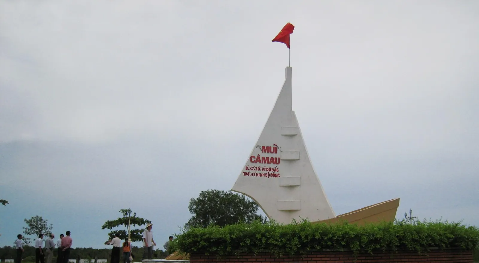
Mui Ca Mau (Cape Ca Mau) is the southernmost point of mainland Vietnam. The provincial portal lists what visitors find at the national tourist area there: the marker for the end of the Ho Chi Minh Road at km 2436, the national coordinate marker GPS 0001, the Lac Long Quan temple, a statue of the Mother, the Hanoi flag tower, and photo-spot sculptures of the cape's signature creatures — the mud snail (ốc len), the mudskipper and the mud crab. The Ca Mau Cape monument is inscribed with the coordinates 8°37′30″ N, 104°43′ E, and a 20.5-metre sea-watch tower gives a view over the forest and the sea.
The cape is not a fixed point. According to the provincial portal, the mudflats here are built up by silt and push 50 to 80 metres further out to sea every year, with new banks such as Con Ong Trang first colonised by grey mangroves. In the northern winter, flocks of migrating birds stop on these mudflats to feed.
Bring sun protection and water for the boat. The cape itself is a place for a slow look around before you head into the forest, not a full day of sightseeing on foot.
Make time for the local food
What to eat and where to look
Ca Mau mud crab (cua biển Cà Mau)
The province's best-known product. The provincial portal says Ca Mau leads the country in mud crab, mostly raised extensively in shrimp ponds under the mangroves, and lists grilled, boiled, salt-roasted and tamarind crab and crab noodle soup (bánh canh cua) among the ways to eat it.
- Where to look
- Seafood restaurants in Ca Mau city and at the cape.
- Fit it into your day
- A long dinner in the city after a boat day; the portal says crab is at its fullest around the seventh and eighth lunar months.
Crab is usually sold by weight: agree the weight and price before it is cooked. Shellfish allergy.
Seafood hotpot (lẩu hải sản)
A sweet-sour hotpot of fish, shrimp, squid, fish cake, crab and clams in a pork-bone broth with tamarind, tomato and pineapple, with water greens and lotus stems dipped in as you go. The portal says almost every restaurant in Ca Mau serves it.
- Where to look
- Any busy restaurant in the city; at Dat Mui, local catch from the mangroves.
- Fit it into your day
- A shared dinner for three or more, eaten with rice or noodles.
Pork broth and fish sauce; ask before ordering if you avoid shellfish.
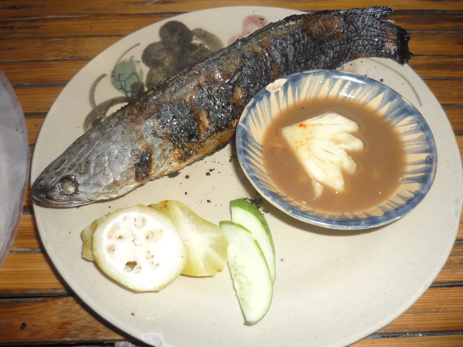
Grilled snakehead (cá lóc nướng trui) and U Minh fish-sauce hotpot
Whole snakehead grilled in its skin over a straw fire, peeled and eaten with field herbs, and lẩu mắm, a hotpot built on fermented fish. The portal lists both among the dishes to try around U Minh Ha, alongside braised climbing perch and eel hotpot.
- Where to look
- Community and eco sites in the U Minh Ha forest, such as Muoi Ngot and Huong Tram.
- Fit it into your day
- Lunch on the U Minh day.
Lẩu mắm is strong-smelling. Some U Minh menus also include field rat, snake and bee larvae: ask what is in a set meal.
Grilled yellow catfish with ginger fish sauce (cá trê vàng nướng)
Whole field catfish grilled over charcoal until the skin blisters, eaten with a basket of field and forest leaves and a dipping sauce of pounded ginger, chilli and garlic in fish sauce — a country dish the portal calls familiar to everyone in Ca Mau.
- Where to look
- Local restaurants serving country food (món đồng quê) in and around the city.
- Fit it into your day
- The portal says the fish are fattest in the field-fish harvest, roughly the 11th to 3rd lunar months; order it with rice at dinner.
Bony; contains fish sauce.
U Minh Ha forest honey
Honey from the melaleuca blossoms of U Minh Ha, collected by the forest's traditional rafter beekeepers; the portal says the dry-season honey, after the flowers open in the third and fourth lunar months, is the most prized, and 'Mật ong U Minh Hạ' has been a registered collective mark since 2011.
- Where to look
- Community sites in U Minh Ha and specialty shops in Ca Mau city.
- Fit it into your day
- A souvenir rather than a meal.
The portal itself warns that adulterated honey is common; buy from producers or labelled U Minh Ha products.
Into the mangroves by boat
Much of the cape is protected as Mui Ca Mau National Park, established in 2003 and designated a Ramsar wetland of international importance (site no. 2088) in 2013; the provincial portal also describes it as part of the UNESCO-recognised Mui Ca Mau world biosphere reserve. Wikipedia gives the park's area as 41,862 hectares, more than half of it coastal. The forest is dominated by Rhizophora (đước) mangroves — so much so that locals call it the đước forest of Ca Mau — with monkeys, langurs, otters, birds and an abundance of shrimp and fish under the canopy.
The provincial tourism department runs four boat routes through the park, from 20 km to 55 km round trip: mangrove and mudflats; the Gieng Troi 'sky well' and primary forest; natural forest succession and Con Ong Trang; and a crossing from the East Sea mudflats through the mangroves to the West Sea mudflats. When we checked on 2026-10-03, the provincial portal listed motor canoes or speedboats costing from 800,000 dong to almost 2.2 million dong per trip, depending on the boat, the route and the group size (up to five, or six to ten people). Confirm the current price and route locally before you set off.
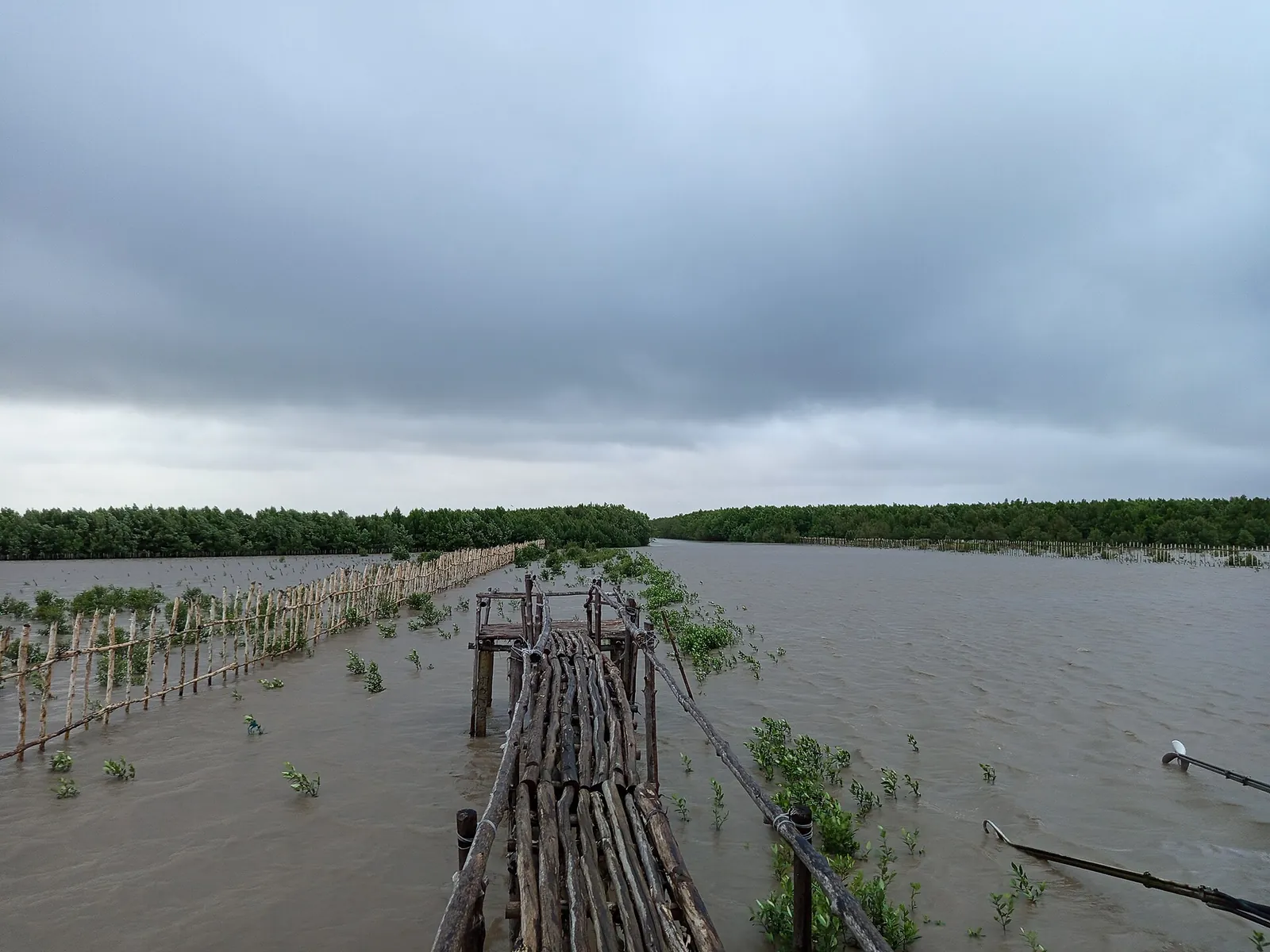
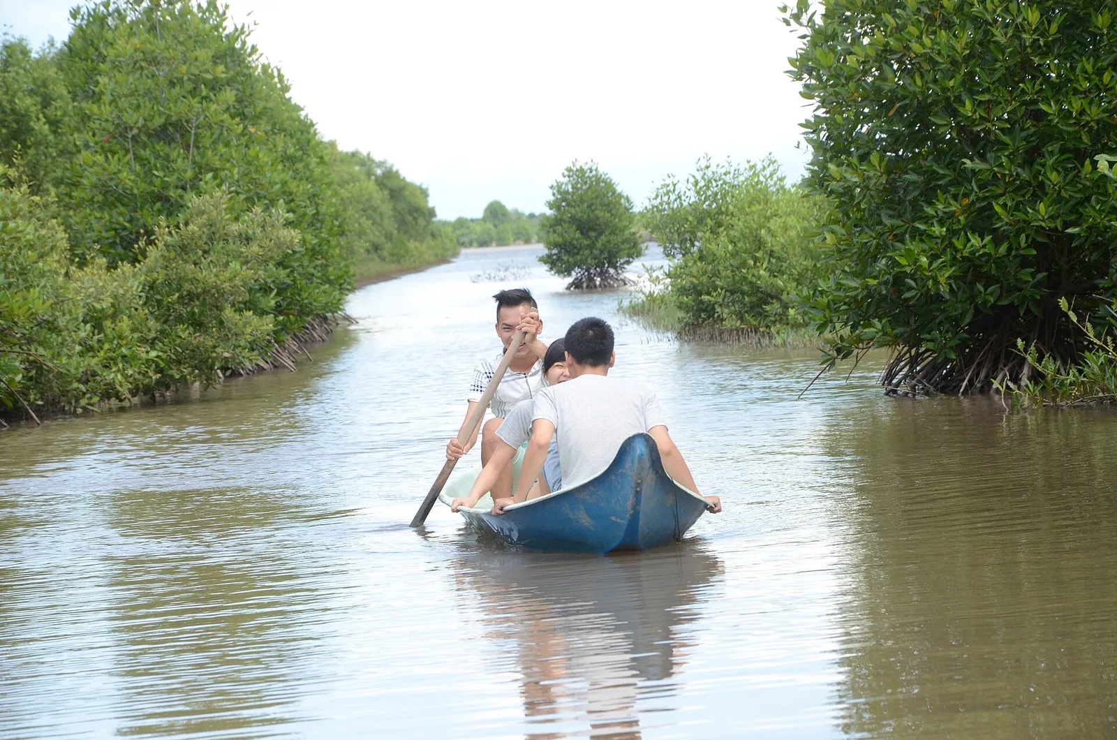
Along the channels you pass stilt houses built for the big tides, caged oyster farms on the river and wooden monkey bridges into the forest; at low tide you can walk out on the mudflats. The portal also describes community-based tourism spots where you can try setting crab traps, harvesting a shrimp pond or netting fish, and have what you catch cooked for lunch. Some of them take overnight guests, which is the way to be on the water early.
U Minh Ha and Hon Da Bac
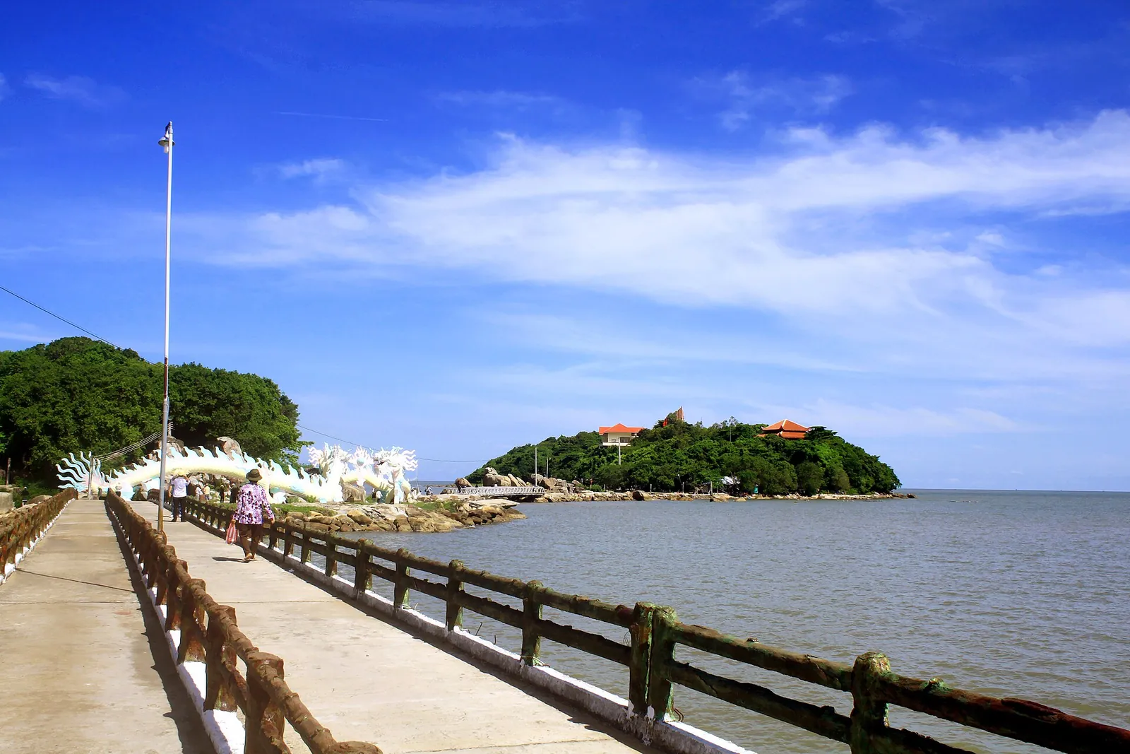
The second day goes west. Hon Da Bac is a cluster of small near-shore islands on the province's west coast. The provincial portal describes a national historic site where Ca Mau's CM12 counter-intelligence operation took place, with a monument, a People's Public Security museum and a temple to Ho Chi Minh; a temple to the whale (cá Ông), sacred to the fishing communities; and natural rock formations called the Fairy's Hand and Fairy's Foot. Seafood is the obvious lunch.
On the way back, stop at U Minh Ha National Park, created in 2006 to protect the low-lying wetland and covering about 83 square kilometres, according to Wikipedia. This is melaleuca (tràm) swamp forest rather than tidal mangrove — the portal describes rivers here running dark brown with forest water in the rainy season — and the portal suggests climbing the forest watchtower for a view over it. Families in the U Minh area have long lived from the forest by keeping bees, fishing, catching eels and growing fruit.
If you want more than a viewpoint, the portal lists eco and community sites in the U Minh Ha forest. Huong Tram has a 300-metre plank walk through the melaleuca and a 15-metre tower; Muoi Ngot is a community site where you can set fish traps, collect wild honey and pick forest vegetables before a country lunch. Expect simple, rustic set-ups aimed mainly at Vietnamese visitors.
Ca Mau city: birds at dusk
Ca Mau city itself is a working canal town where, as Wikivoyage notes, much of the freight still moves by boat. It is not a sightseeing destination, but it has one sight worth timing your day around. The bird sanctuary in the Ho Chi Minh Memorial area, in An Xuyen ward, covers 4.5 hectares; the provincial portal counts more than 10,000 birds nesting there, many of them egrets and herons. Go in the late afternoon, when the flocks return to roost in the middle of the city.
For a festival trip, the Nghinh Ong whale festival at the mouth of the Ong Doc River, on the west coast, runs for three days, on the 14th to 16th of the second lunar month, with the main ceremony on the 15th from 2pm, according to the portal. Hundreds of decorated fishing boats moor along the river, and a lead vessel sails out to sea to welcome the whale spirit back to its temple.
Getting there and getting around
Ca Mau Airport (CAH) began as a French airfield at Quan Long, today's Ca Mau city, so it is close to town. Wikipedia lists flights to Ho Chi Minh City's Tan Son Nhat airport operated by VASCO, Vietnam Airlines' regional arm; the route is small, so check the current schedule before planning around it. By road, Ca Mau is about 370 km from Ho Chi Minh City and 180 km from Can Tho, and Wikivoyage notes sleeper buses from Ho Chi Minh City, including from Mien Tay Bus Station; check the operator and departure point when you book.
For the cape and U Minh, the simplest option is a car with driver, or a tour arranged through your hotel, since both are day trips by road from the city according to the provincial portal's own suggestions. The provincial portal also describes reaching the mangroves by speedboat in a little over an hour. Boats inside the national park are hired at the cape.
Ca Mau sits at the end of the delta's road network, so it pairs naturally with Can Tho and Soc Trang on the way down, or with Ha Tien on the Gulf of Thailand coast if you continue west.
A workable two- or three-night plan
This is an editorial suggestion, not a timetable. Confirm road times, boat routes and prices locally the day before.
- Day 1 — Arrive: fly or drive into Ca Mau, the bird sanctuary in the late afternoon, crab and seafood hotpot for dinner.
- Day 2 — Cape Ca Mau: leave early by road, the GPS 0001 marker and the sea-watch tower, then a boat route through the mangrove national park and lunch at a community site; back to the city, or stay the night near the cape.
- Day 3 — West coast: Hon Da Bac in the morning, U Minh Ha's watchtower or the Huong Tram plank walk in the afternoon, and grilled snakehead for lunch on the way.
Practical questions
How many days do I need in Ca Mau?
Two nights at minimum: one full day for Cape Ca Mau and the mangrove national park, and one for Hon Da Bac and U Minh Ha. A third night lets you sleep near the cape and go out on a boat early.
Can I visit Cape Ca Mau as a day trip from Ca Mau city?
Yes. The provincial portal's suggested programme is a day trip by road from the city to the cape, with time for a boat route through the mangroves. Leave early, since you need most of the day.
How much is a boat trip through Mui Ca Mau National Park?
When we checked on 2026-10-03, the provincial portal listed 800,000 dong to almost 2.2 million dong per trip, depending on the boat, the route (20 to 55 km round trip) and the group size. Confirm locally.
How do I get to Ca Mau?
Fly to Ca Mau Airport (CAH) from Ho Chi Minh City, or travel by road: about 370 km from Ho Chi Minh City and 180 km from Can Tho. Check the current flight schedule, as the route is small.
When is the best time to visit Ca Mau?
December to April, the drier months, is easiest for long boat days. From May to November the south has its wet season, usually with afternoon downpours. Crab is at its best around the seventh and eighth lunar months.
Is Bac Lieu now part of Ca Mau?
Yes. On 12 June 2025 the National Assembly merged Bac Lieu province into Ca Mau province, so older maps and guides may still show them as separate provinces with district names that no longer exist.
Sources and checks before you travel
Reference sources for the version dated 3 October 2026. Confirm opening times, access, transport and conditions for your travel dates.
- Ca Mau Provincial Portal: Tour programmes (Chương trình tham quan) ↗ — opens in a new tab
- Ca Mau Provincial Portal: Exploring the Ca Mau mangrove forest ↗ — opens in a new tab
- Ca Mau Provincial Portal: Boat routes through Mui Ca Mau National Park ↗ — opens in a new tab
- Ca Mau Provincial Portal: Bird sanctuary at the Ho Chi Minh Memorial area ↗ — opens in a new tab
- Ca Mau Provincial Portal: Ca Mau mud crab ↗ — opens in a new tab
- Ca Mau Provincial Portal: Seafood hotpot ↗ — opens in a new tab
- Ca Mau Provincial Portal: Grilled yellow catfish with ginger fish sauce ↗ — opens in a new tab
- Ca Mau Provincial Portal: U Minh Ha forest honey ↗ — opens in a new tab
- Ca Mau Provincial Portal: Nghinh Ong festival ↗ — opens in a new tab
- Ca Mau Provincial Portal: Hotels in Ca Mau ↗ — opens in a new tab
- Wikipedia: Cà Mau province ↗ — opens in a new tab
- Wikipedia: Mũi Cà Mau National Park ↗ — opens in a new tab
- Wikipedia: U Minh Hạ National Park ↗ — opens in a new tab
- Wikipedia: Ca Mau Airport ↗ — opens in a new tab
- Ca Mau Provincial Portal: Trem River ↗ — opens in a new tab
- Wikivoyage: Ca Mau ↗ — opens in a new tab
- Vietnam National Authority of Tourism: Weather and climate in Vietnam ↗ — opens in a new tab
Does this experience fit your route?
Ca Mau's boats and drivers are mostly arranged locally. If you are coming down through the delta, compare Can Tho's river tours for the first leg, and book Ca Mau through your hotel the day before.
Browse relevant experiences on Viator ↗ — opens in a new tabAffiliate link · Book with ViatorPhoto credits
Mangrove forest and the sea at Cape Ca Mau, the southern tip of mainland Vietnam
Photograph: Colalumbu — opens in a new tab · CC BY-SA 4.0 — opens in a new tab
Changes: Resized and converted to WebP; displayed with responsive crops. · Original photograph and licence details ↗ — opens in a new tab
The boat-shaped monument at Cape Ca Mau
Photograph: HaMinh1997 at Vietnamese Wikipedia — opens in a new tab · CC BY-SA 3.0 — opens in a new tab
Changes: Resized and converted to WebP; displayed with responsive crops. · Original photograph and licence details ↗ — opens in a new tab
Mangrove planting on the mudflats at Dat Mui
Photograph: Alphama — opens in a new tab · CC BY 4.0 — opens in a new tab
Changes: Resized and converted to WebP; displayed with responsive crops. · Original photograph and licence details ↗ — opens in a new tab
Paddling through a mangrove shrimp pond in Nam Can, Ca Mau
Photograph: Nguyendang293 — opens in a new tab · CC BY-SA 4.0 — opens in a new tab
Changes: Resized and converted to WebP; displayed with responsive crops. · Original photograph and licence details ↗ — opens in a new tab
The walkway to Hon Da Bac on Ca Mau's west coast
Photograph: Bùi Thụy Đào Nguyên — opens in a new tab · CC BY-SA 3.0 — opens in a new tab
Changes: Resized and converted to WebP; displayed with responsive crops. · Original photograph and licence details ↗ — opens in a new tab
Cá lóc nướng trui, snakehead grilled whole in its skin
Photograph: Memberofc1 — opens in a new tab · CC BY-SA 3.0 — opens in a new tab
Changes: Resized and converted to WebP; displayed with responsive crops. · Original photograph and licence details ↗ — opens in a new tab